10 DESERT BROOK RD
Owner Information
HENDERSON CATHRYN
10 DESERT BROOK RD
WRENTHAM, MA 02093


Property Details
10 DESERT BROOK RD is classified as a Single Family Residential (Ranch).
The primary structure on this property was built in 1978. There are 4,130ft2 of built area within this property. There is 1,704ft2 of residential/living space within this property. This property is listed as having 6 rooms.
10 DESERT BROOK RD is valued at $463,400. The land is valued at $287,000 and the structures are valued at $176,400.
This property is in Zone 02. Confirm with local Zoning Board authorities to ensure there are no overlays or other easements on this property.
The most recent deed for 10 DESERT BROOK RD is recorded at the local registrar in Book 28919, Page 192. 10 DESERT BROOK RD was last sold on Thursday, June 30, 2011 for $390,000.
Assessment data from fiscal year 2022.
Flood Data
According to the FEMA National Flood Hazard Layer, this property does not appear to be in a flood zone. It may also be in an area not yet reviewed. Nonetheless, confirm this information prior to taking any action.
To view the flood hazards around this property, create a FEMA "Firmette" Map of the area around 10 DESERT BROOK RD.
Broadband Internet Providers
| Provider | Type | Bandwidth (mbps) | |
|---|---|---|---|
| HughesNet | Satellite | 25 | 3 |
| Viasat Inc | Satellite | 100 | 3 |
| Verizon New England Inc. | DSL | 1 | 0 |
| Verizon New England Inc. | Fiber | 940 | 880 |
| Comcast | Cable | 1000 | 35 |
| GCI Communication Corp. | Satellite | 0 | 0 |
| VSAT Systems, LLC. | Satellite | 2 | 1 |
Broadband service provider data from December 2020.
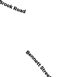
Adjacent Properties
- 96 BENNETT ST
Single Family Residential owned by SIMPSON DAVID R - 100 BENNETT ST
Single Family Residential owned by MARLAND STEPHEN L - 20 DESERT BROOK RD
Single Family Residential owned by GREENBERG ERIC A - 120 BENNETT ST
Single Family Residential owned by JEANETTI JOSEPHINE - 110 BENNETT ST
Single Family Residential owned by TAFT TANYA L - 94 BENNETT ST
Single Family Residential owned by SHAPIRO SETH T